Top mobile phones you can't live with

Get paid To Promote at any Location
Showing posts with label Trekkings. Show all posts

Friday, April 9, 2010

Hill Stations of Tamil Nadu

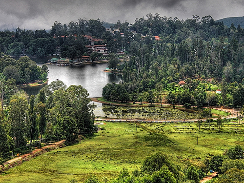
Lake View, Ooty
Famous for the most beautiful hill stations of India, Udhagamandalam or Ooty can be said to be the Hill Capital of Tamil Nadu. Howevern the two smaller yet quieter hill resorts Coonoor and Kotagiri nearby are more preferable to some as people love to witness the tribal life of the Badagas and the Todas in the tiny village of Ketti on the way to Coonoor. Kodaikanal enchants its visitors with the verdant Pali hills while Yercaud is known as the 'Ooty of the Poor'. However, the aromatic coffee plantations and orange groves, the serene quiet surroundings at a much cheaper rate make it a better option than the more reputed hill resorts such as Ooty and Kodaikanal. Ketti is famous for having the highest railway station in the country at an altitude of 7,000 ft above the sea level in the lap of the Nilgiri Mountains of South India. The world-famous tea farms of Ooty make it the most desirable picnic spot. Coonoor at an altitude of 1,858 m above sea level, is the second largest hill station in the Nilgiris. Kotagiri, however, is the oldest hill station of the Nilgiris and was once a British hill resort. It is quieter than Ooty and features Elk Falls, Kodanad Viewpoint, Catherine Falls, salubrious climate and a wonderful golf course along with thick, deep impenetrable forests called 'Sholas'.


Kodaikanal:
Situated at an altitude of more than 6854 ft above sea level, Kodaikana is located on the southern tip of the upper Palani Hills 120 km northwest of Madurai. A typical hill station, Kodaikanal offers you boat rides, nature walks, hiking, trekking and rock-climbing. The delectable taste of homemade chocolate and cheese is a specialty of Kodaikanal, also referred to as Kodai. Surrounded by thick Shola Forests and scenic greenery, Kodi leads to some of the South India's best trekking terrain. A favorite among the honeymooners, the highlight of the city is a centrally located star-shaped lake.

Nilgiri Hills:
'Nilgiris' or 'Blue Mountains' rise to an altitude of 2,280 m to 2,290 m above sea level. Situated at the confluence of the Western and the Eastern Ghats known as the Sahayadri Hills, Nilgiris offers some of the most panoramic views of Deccan India. Some of the most well-known highlights of Nilgiris are Udhagamandalam or Ooty, Coonoor, Kotagiri, Doddabetta peak, Mudumalai Wildlife Sanctuary, 180-ft high Laws Falls, Dolphin's Nose, a unique rock of tremendous proportions jutting out of the face of the hillside, Catherine falls, Kodanad Viewpoint, which offers panoramic view of the plains and the eastern slopes of the Nilgiris, Mukkurthi Peak and National Park and Pykara known for well-protected fenced sholas, Toda settlements, undisturbed grassy meadows and a good wildlife habitat along with Pykara Dam, Pykara falls and the reservoir.

Ooty:
The haven for adventure tourists, Ooty offers a number of facilities for adventure sports such as trekking, hiking, rock-climbing and hand gliding. Often referred to as 'the Queen of Hill Stations', Udhagamandalam or Ooty is situated in the lap of the Nilgiri ranges. At an altitude of 2290 m above sea level, it is just 105 km away from Coimbatore and has a salubrious climate. A blue misty haze envelops the range, giving it a divine look. Wildlife enthusiasts would certainly enjoy the trip to the sprawling Mudumalai Sanctuary nearby. Amateurs may choose to join hang-gliding courses at Ooty that are organized every year from March to May along with fishing camps. One needs license for fishing and angling in the various streams and lakes of Ooty and the main catch are usually Goad Trouts, Carps and mixed water fishes.

Yercaud:
Situated at an altitude of 4,920 ft above sea level, Yercaud is not as popular as Ooty and Kodaikanal. Nestled amongst the Shevaroy hills of the Eastern Ghats, the extraordinarily beautiful hill resort is blessed with natural beauty and a salubrious climate. Also known as the 'Ooty of the Poor', it is much quieter and cheaper than its more popular hill mate. The aromatic coffee plantations and orange groves make it even more desirable to those who are looking for the places where they can get rid of the din of the daily lives and want a break from the strenuous city lifestyle. The highest point in Yercaud is Shevaroy temple, situated at a height of 5,326 ft above sea level.

Yercaud

Yercaud

Sunset, Yercaud
Situated at an altitude of 4,920 ft above sea level, Yercaud is not as popular as Ooty and Kodaikanal. Nestled amongst the Shevaroy hills of the Eastern Ghats, the extraordinarily beautiful hill resort is blessed with natural beauty and a salubrious climate. Also known as the 'Ooty of the Poor', it is much quieter and cheaper than its more popular hill mate. The aromatic coffee plantations and orange groves make it even more desirable to those who are looking for the places where they can get rid of the din of the daily lives and want a break from the strenuous city lifestyle. The highest point in Yercaud is Shevaroy temple, situated at a height of 5,326 ft above sea level. Yercaud is an amalgamation of two Tamil words 'yeri' and 'kaadu' meaning lake and forest respectively. Yercaud was discovered by the British in the early 19th century. It is famous for its educational institutions such as the Sacred Heart Convent for girls, Montfort School for boys and the Holy Cross Novitiate House.

Yercaud Lake is one of the prime attractions of the hill station, surrounded by well-groomed lush green gardens and well-wooded trees. The Summer festival held in May is not to be missed. One can opt for paddling or rowing boats for a trip around the lake. There are a number of beautiful parks surrounding the lake such as Anna Park, Lake Park, Gandhi Park and Children's Park. Lady's seat offers breath-taking views of the Ghats, especially at night. Towards the extreme right, one can see Mettur Dam from here. More than 100 years old, Holy Trinity Church is well maintained. The other popular churches include the Sacred Heart Church, Lutheran Church, St Joseph's Church and The Retreat Church. National Orchidarium with India's third largest orchid house, 300 ft high Killiyur waterfalls, the Servaroyan temple atop the Servaroyan hill and the Small Lake famous for being fed by seven wells are some other highlights of the city.

Ooty

Ooty

Sims Park at Ooty
The haven for adventure tourists, Ooty offers a number of facilities for adventure sports such as trekking, hiking, rock-climbing and hand gliding. Often referred to as 'the Queen of Hill Stations', Udhagamandalam or Ooty is situated in the lap of the Nilgiri ranges. At an altitude of 2290 m above sea level, it is just 105 km away from Coimbatore and has a salubrious climate. A blue misty haze envelops the range, giving it a divine look. Ooty passed hands from Tippu Sultan to the East India Company from Tipu Sultan by the treaty of Srirangapatnam in 1799. Though it was in 1603 that the first European visited the Nilgiri hills by the name of Rev. Jacome Forico who was a priest, it was not until 1822, that Ooty was finally founded. John Sullivan, the Collector of Coimbatore, is credited as its founder who encouraged settlement here by building a Stone House, today known as 'Kal Bangla'.

Today, Kal Bangla is used as the Chamber of the Principal of the Government Arts College while the base camp at Parsons valley offers several trekking points within Western Ghats. Wildlife enthusiasts would certainly enjoy the trip to the sprawling Mudumalai Sanctuary nearby. Amateurs may choose to join hang-gliding courses at Ooty that are organized every year from March to May along with fishing camps. One needs license for fishing and angling in the various streams and lakes of Ooty and the main catch are usually Goad Trouts, Carps and mixed water fishes. However, it is the sprawling tea estates that have earned the real fame for Ooty and the annual Tea and Tourism Festival held in January here has gained international repute. The tea lovers from all over the world come here to witness the occasion. Ooty also offers beautiful and interesting treks with natural surroundings that can be chosen according to the desired distance, altitudes and terrain.

Kodaikanal

Kodaikanal

Green Valley, Kodaikanal
Situated at an altitude of more than 6854 ft above sea level, Kodaikana is located on the southern tip of the upper Palani Hills 120 km northwest of Madurai. A typical hill station, Kodaikanal offers you boat rides, nature walks, hiking, trekking and rock-climbing. The delectable taste of homemade chocolate and cheese is a specialty of Kodaikanal, also referred to as Kodai. Surrounded by thick Shola Forests and scenic greenery, Kodi leads to some of the South India's best trekking terrain. A favorite among the honeymooners, the highlight of the city is a centrally located star-shaped lake. There are interesting slopes covered with thick forests, pleasantly cool climate, cascading waterfalls and steep rocky outcrops that make it a perfect tourist destination.

The spectacular Kurinji Andavar temple dedicated to Lord Murugan is one of the most beautiful vantage points that provide panoramic views of Kodaikanal and its suttoundings. The Flora and Fauna Museum of the Sacred Heart College in Shembaganur has a good collection of stuffed animals and about 300 species of orchids at its Orchidarium. The venue of annual horticultural shows held in May, Byrant Park features tiered flowerbeds, rare collection of flowers, grafting and hybrids. One can opt to cruise in the star-shaped Kodai Lake or choose to stroll or bike around this gorgeous lake. Then there are Pillar Rocks, a series of granite cliffs more than 100 m in height rising abruptly and towering above the hillside. While at Kodaikanal don't miss out on the Bear Shola Falls, which is so called because once the bears could be easily spotted drinking water upstream from here. The other highlights are Orchid House and Silver Cascade Waterfalls.

NILGIRI HILLS

Niligiri Hills

Nilgiri Hills
'Nilgiris' or 'Blue Mountains' rise to an altitude of 2,280 m to 2,290 m above sea level. Situated at the confluence of the Western and the Eastern Ghats known as the Sahayadri Hills, Nilgiris offers some of the most panoramic views of Deccan India. Some of the most well-known highlights of Nilgiris are Udhagamandalam or Ooty, Coonoor, Kotagiri, Doddabetta peak, Mudumalai Wildlife Sanctuary, 180-ft high Laws Falls, Dolphin's Nose, a unique rock of tremendous proportions jutting out of the face of the hillside, Catherine falls, Kodanad Viewpoint, which offers panoramic view of the plains and the eastern slopes of the Nilgiris, Mukkurthi Peak and National Park and Pykara known for well-protected fenced sholas, Toda settlements, undisturbed grassy meadows and a good wildlife habitat along with Pykara Dam, Pykara falls and the reservoir. To its west lies Kerala while there is Mysore to the north of the hills and Coimbatore covers its east and south. It has been carved as a district known as Nilgiris district with its district headquarters at Udhagamandalam or Ooty.

The highest peak of Nilgiris is Doddabetta, which reaches up to an altitude of 2,623 m above sea level. The beautiful scenery of Nilgiris with steep hills, narrow valleys, rivers and rivulets rushing downhills, fine waterfalls, lush green forests and the pleasant temperate climate make it one of the most desirable hill-tour destination. Along with a number of popular hill resorts and major tea estates in South India, Nilgiris got its name from the misty blue haze that envelops the distant hills and blue-violet 'Kurinji' flowers that bloom to cover the hills like a carpet once every 12 years. A trekker's paradise, Nilgiris have been so planned and landscaped by Nature itself that there are number of treks in all directions that are thrilling, exciting and adventurous all at once. Trekking through Nilgiris is perhaps the best way to come closer to Nature and its blessings. One may opt for the guided tour while trekking too.

Saturday, January 23, 2010

GUNDYA - KABBINALE - OMBATTU GUDDA - HOSAKERE TREK IN MAY

GUNDYA - KABBINALE - OMBATTU GUDDA - HOSAKERE TREK.............

Sandeep is a great trekker in india. He shares some of his experiences................

Let me start with an apology to all those who have conquered these mythical hills long long ago and kept it as one of the most well kept secrets in Western Ghats. Also, let me pray for all those who were lost here, including people I knew. I dont want non-serious trekkers coming to this place and making it another garbage area and I am trying not to put so much information here, to help non-serious trekkers or kill the suspense, thrill and challenges involved in this trekking trail. For a long time, Ombattu Gudda had been a secret of only hard core trekkers and by now, the place has accounted for a few trekkers getting lost and even some lives! While praying for no more mishaps in this area, I also hope that the mystery of these hills remain as it is.
I first heard abt it some four years back, but could not proceed further due to the lack of information. In recent times, with a slew of blogs available in the internet, the maps from Survey of India (map #48, p/9 1:50,000 or map #48 s/w and n/w, p/9 1:25,000) and equipments like GPS and compasses, more people have conquered this place. Ofcourse, even more are getting lost in those jungles! The first time I seriously started thinking about Ombattu Gudda was as recent as Jan 2008. A little later, I saw Peter & Chennai Trekkers[1] planning to head to Ombattu Gudda. But their plan fell around the Vishu weekend and I couldnt have joined. Instead, I thought of going there myself and almost planned it in March end, if not for a last minute dash in office. Luckily, for me, Peter could not carry on with his original plan and re-scheduled it in May ... and I gladly joined!
Ombattu Gudda / Ombattu Gudde / Ombathu Gudde is @ an altitude of 971m in the Kabbinale reserved forest range accessible from Hosakere (near Mudigere) as well as from Gundya. The usual trek trail is to start from Gundya check post (in NH48 / Mangaluru / Mangalore highway), head towards a water falls, climb up Ombattu Gudda, get down @ Hosakere and take a bus to Mudigere. We too planned to do the same over a weekend ... but the only difference with the normal groups heading to Ombattu Gudda was the team size. Peter had an ambitious team size of 31 people! Big crowd for even a small trek around Bengaluru (Bangalore) and a nightmare to manage @ a place as treacherous as Ombattu Gudda!
Anyways, on a friday evening, Preethu and I reached @ Bengaluru railway station, were we spotted Ramki, Anala, Priyanka and Krishnamoorthy waiting with truck load of cartons, filled with water bottles! Before 10 we had full house, with 18 people from Chennai and 3 people from Tuticorin landing @ the railway station. All the people, except Ravi, from Yercaud Trek was there for this trek as well and it was nice meeting all of them again. I also knew a few others like John and Aditya thru mails, though I've never met them. Divya had a surprise in store wearing a beautiful white saree and we all were left wondering if shez joining the trek or heading for a fashion show in Bengaluru ;-) Another surprise was a 2nd Sandeep from Chennai, whom we'll refer as Sandy from now ;-) We took turns to shift the luggage (some heavy cartons containing water bottles) to the back side of the station, were our private bus waited.
Since, most of the people from Chennai had missed their dinner, we stopped at a dhaba on Mangaluru road. At the dhaba, a few people were reported to have fainted after seeing a lady with open hair and wearing a white saree. I wud also have fainted, had I not recognized that the ghost which scared the people was actually Divya!


                                          Getting Ready for the Plunge


We reached Sakleshpur by around 4 in the morning and fortuanately was able to take the Shiradi ghats (in spite of the road repair which was going on) to reach Gundya check post by day break. After a small break for changing, distributing the supplies, packing the bags and snaps, we took the jeep track towards Ombattu Gudda @ abt 6.30.


                                        Jeep track is now a Footpath


The jeep track initially was amidst houses; but, as we progressed, it narrowed down and became a small footpath. There were some signs of moisture and good greenery even @ this peak summer; the path had a good 'junglee' feel about it. We had our first share of confusion when the road was crossed by a dried up stream leading to another path to the right, which we soon found to join back the main path :)
I was carrying a heavy bag, with a tent, lenses, camera and two sleeping bags and soon realized it was more than I can handle. With the humidity, I also started sweating profusely and its not a nice feeling when sweat impedes the vision and drops into the mouth. It was a welcome break, in little more than an hour from the main road, when we found ourselves near the first stream, which was beginning to dry in the summer. I gladly washed my face and hair in the cool waters to brace myself for a tough trek ahead. It is here that we first spotted leeches, generating interest, especially in those who havent seen them yet!


                                        Miles to go before we sleep ...


Next break was another hour away, in an open land, from where we could catch a glimpse of the mountains (not Ombattu Gudda, I guess). The sunlight had begun to seep thru' the forest and it was getting hotter. Hence, the third leg took a little more time than the first two. The number of obstacles, fallen trees, branches growing into the path ... etc, were also more now. I was finding my bag a little too heavy by now and decided to empty some of the things I carried (atleast the milk packets and chappathis) at the breakfast point, so that I could move along the rest of the group comfortably. Preethu spotted a leech moving inside her dress and had to search a while to pick it up. It was all swollen and happy by then after a good feast!


                      Dip in the Stream or Hike up the Mountains? We want both!


By about 9.30 we were near the Kabbinale Hole, where we planned to get fresh and take our breakfast - chappathis and jam. The stream was a li'l stagnant on one side, but had clear water on the other side. Peter jumped into the water straight away, followed by the rest of the gang and started making merry in water. Mahalingam, the youngest dynamite in our group, seemed the most ecstatic in water, with Srikanth and Sandy splashing water on him and each other. I was content initially in photographing the action, but the lure of water, as always, finally got to me. Armed in my lungee, I plunged. Soon, Peter reminded us that the major part of the trek is only going to start now and we need to move fast to make it to the grass lands before the light fades.
We ended up spending an hour in water, before starting to move again. It is from here that the real trek started. Peter, Arul, Ramki and Shyam, the leaders of the group had plans made too. The idea was to let Arul lead the group, closely followed by Peter, then Ramki. Shyam and Amal was to bring the rear up. We had a walkie-talkie set as well to make sure there is enough communication between front and rear, with Amal and Peter carrying it for now. I was a little late packing up after the time in the pool and four of us (Preethu, Amal, Shyam and myself) ended up in the rear.
The instructions from the walkie-talkie (from Peter) was to continue along the river and we did just that. But after a few minutes of making our way through the bushes and rocks, unable to spot others, doubt crept in. A little ahead, we spotted some more people including Ramki, but soon realized that they were as lost as us! In between, somebody told that two guys started walking up the hill (and away from the river) and Amal volunteered to go and hunt for them. It was all chaos, until, we spotted Srikanth coming back, looking for us. Soon, we spotted Peter and the rest of the gang waiting for us. We all looked at each other, as if to say: "Welcome to Ombattu Gudda - the paradise for people who wants to get lost!"
Looks like most gangs, heading to Ombattu Gudda, are getting lost around this stretch. If u observe the map carefully, we need to head north a little while from the river and most of the people heads towards the jungle right here. We should ideally, follow Kabbinale Hole for almost an hour before turning north among other smaller streams. For most part of the trek, the path is pretty close to one of the streams till the last climb to the grasslands.


                                                River and Rocks


Peter's verdict after this initial goofup (which took about an hour to rectify) was straight-forward. We should move in a group! From here on Shyam took up the sweeper responsibilities to heart and Arul was excellent as the path finder! We were walking along the river now and it went on for some time. The path criss-crossed the river every now and then and we kept following the stream, with Peter and Arul rechecking positions on GPS and map every now and then to make sure that we are on the right track. One bad thing that happened during all this was one of the walkie-talkie falling in water and becoming useless. This made things a little more diffcult since moving in a group was a must now.
The going was tough with slippery rocks and time running out. It was also important to make sure that everybody kept together. Shyam kept saying "Move People ... Move it ..." and made sure that the people behind (including me) kept up with the front runners, which included Arul, Sabith, Rudee, Vivek, Ramki, John, Anala ... among others. There were people like Prem, Srikanth, Sandy and Sreekumar (I actually forgot a few names here ... 31 people u know!!!!), apart from Peter and Shyam, who were helping out others to sail through the slippery rocks.
Preethu had a bad cramp in between but was ready to go in no time and even refused to hand over her bag, in spite of Peter and Prem offering to carry it. While, we were chugging along, the water in the stream was crystal clear, all along. Any time u r thirsty just sit down and drink water ... wow!!! Btw ... all water bottles were emptied to reduce the weight and we were carrying only empty bottles. Why carry artificial mineral water when we are walking next to a crystal clear water stream?


                                          Revelling @ the Falls


After walking for abt 3 hrs along the river, we finally reached a waterfall @ abt 2'O clock. It was time for a break. Lunch boxes (bread and jam) were opened up and some people (the first one being Peter, himself) headed to the waterfall to get soaked. As usual, I spent a while with the camera, but, ultimately headed to the waterfall. My trousers and t-shirt was dripping wet coz of the sweat and I decided there was no point in trying to change it before heading to the waterfalls.
In another hour we climbed up by the side of the falls and headed up. The trail got steeper from here on and the rocks were slippery. This ensured that we took more time to head towards our camping point. The final climb which was supposed to take us to the grass lands never seemed to come. According to one of the blogs, this was abt 2km vertical climb and a very tough one. Obviously, this wud have been a tough one to do once its dark ... and that meant we had to hurry.
Divya, already figured out that walking in the slippery rocks is easier without the shoes and Preethu started using the same tactics with some success. We crossed one stream after the other and climbed one slippery rock after the other and it was getting darker and darker. Arul had been going ahead every now and then and coming back with the news of "Therez a path ahead" and Shyam kept pushing people with his trademark "Move people ... Move it ..." The desperation levels of some reached the levels of saying "Whoever says move ... I hate them all!", "I am not moving an inch now!", "I hate that guy Arul ... cant we camp somewhere here???" ... etc etc. I am not saying who said all these ... c'mon ... u guys can guess!!!
At abt 6, with darkness already looming large, I suggested camping near the falls and Peter supported me. I was actually waiting for that scary 2km vertical climb and didnt want to do that in the dark. But, Arul already moved ahead and we decided to follow him. Time for trekking in the dark along a 70 degree (and possibly vertical later) ascend! Frustration had crept in by now and even Shyam started shouting "Is there any space to camp up there?" Amal, headed up to look for people at the top and see if he can get any news.
Finally, by the time it was pitch dark, Amal came back with the news that there indeed is camping space @ the top. This, surely elicited responses like "Liars ... I cant walk in this night!". People from the top kept assuring that the grassland is nearby and people @ the rear kept throwing tantrums! In between, Arul himself came down and assured that the 'promised land' is just abt 10mins! People showed us lights and kept pulling up the entire group. Shyam, Rudee, Amal ... etc came down and helped to pull up people. Finally, after numerous falls, slipping and even crying, by abt 8'O clock everybody was up and sure enough ... there was 'promised land' at the top ... lush green and bright even in the night, with a view of the sky and the far away hills!
Lying down all exhausted @ the 'promised land', serious questions came to my mind about my own fitness! This trek, though long, wasnt exactly a tiring one and the exhaustion I was facing wasnt really justified. Infact, I'd been feeling that I've slowed down considerably in the past few years ... but never as bad as this. I thought of a few solutions, like cutting down the comfort and carrying lighter sleeping bags ;-), cutting down further on lens & photo equipments, cutting down on backup items like milk packets. Someone even suggested shaving my hair and beard to save on weight ;-) ... but I knew that its all excuses. The only weight that really mattered was somewhere near the tummy (which I usually hide for photos by holding the breath!) ... with a little more belief and some effort to stay fit, I shud be able to do better!
Thank god, the 2km vertical climb never came - it shud either be an exaggeration or a wrong way. I felt that, since we did the trek during summer, climbing along the water falls was possible and we could avoid that 2km vertical climb. Thnx to Arul, the path finder, and Peter for taking us through the best route possible. In hindsight, getting up here after a climb in the dark was the best thing we did. It not only made things doable for the next day, but also saved us from the dangers of camping near a water source in summer, with wild animals roaming around. Also, the last water source was just behind us and it was always possible to go down and fill the water bottles needed for the following day and cooking. Later, Shyam also located a climb up to another hill, which might have been the 2km vertical climb, straight up from the water falls.
Not everybody was as beaten as I was ... and some of them quickly cut grass around the fire area, collected water, setup the campfire and prepared the cup noodles and soup. I slipped into the lungee (again!), gobbled up the dinner, spread the tent, sleeping bags and soon crashed into a good sleep. There were some initial worries of wild animals and lying in the open, but I doubt if that affected anybody's sleep :)
Next day, we were all ready by 7, with Peter, Arul and Srikanth already gone down to fill up the water bottles. There are no water sources in the hills from now on and it was important to carry enough water. When I looked around, there were peaks all around us, but the map says Ombattu Gudda is towards North-east. Arul, as before was leading the group, with the rest of the gang following. We started off towards the North - East direction, but slowly started drifting southwards as we kept going down through the bushes. Peter, smelt a 'bug' and rushed to the front, suggesting not to lose the attitude we gained. To correct the 'bug', everybody headed back to the base camp and after more discussion, headed a little west of north, descended a little and then started climbing up again. In abt 20 mins time we were near another grassland with clearer views. Looked like, this is were the notorious 2km vertical climb landed!


                                          Trying hard not to look beaten ...


Our camping site, as per Peter's GPS equipment was @ a height of about 560m and we had to reach a height of 971m @ Ombattu Gudda. Hence, it was quite important not to lose altitude. Our path, even now was among the bushes, occassionaly with a view of the surroundings. But, as soon as we reached the next grassland, @ abt 8.30, it all changed. There were some beautiful views on offer all around us. Lush greenery till the horizon, punctuated with dark green areas of thick shola forests, covering mountain ranges on all four sides. We had one more steep climb ahead of us, again to the North-East direction, which took us to even more heights with gentle breeze. Now, the views were good and all the tiredness of a hard trek was beginning to pay!


                                               Up Up & Away


Kissing the Clouds and Looking @ the Valley ...
We opened up our remaining food packets (bread, chappathi, jam, ketchup) and had it for breakfast. At 9.30 we started climbing again and proceeded steadily to the next hill in another half an hour. Here, John spotted a few orchid flowers and went to collect the flowers. We were almost in celebration mode with only abt 200m ascend left and tiredness already gave way to excitement of finally making it to the Ombattu Gudda. Before 11, we could see the jeep track heading to Hosakere to our left when we reached the hill just before Ombattu Gudda. From here, the jeep track may be accessed to our left (North-west direction) and Ombattu Gudda to our right (eastwards). We had a short break, left our luggages there and headed to our final frontier. In spite of a tiring day behind us and an option of staying back and waiting for the rest of the gang, only 3 people stayed back. Actually, by the time I even started from here, I saw people like Sabith and Rudee running towards the peak!


                                   The Final Frontier!


                               Its Photo time Boys ... Amal and Shyam!


From here to Ombattu Gudda peak was straight forward. Couple of ups and downs, enjoying the views around and taking snaps. Ombattu Gudda is definitely not the tallest peak around. There were even more majestic peaks all around us, seperated by deep valleys and thats one more reason why the surroundings looked so beautiful!


                         Thnx for Saving my life ... Preethu with Prem and Sandy


At abt 11.30, we were at the top of Ombattu Gudda. It was time for photo sessions and Preethu wanted a pic with two of her best buddies Prem and Sandy, who literally pulled her up for most part of the trek. Infact, she wanted a paragraph to be dedicated to these two :) Speaking abt dedication, one thing that Peter used to motivate people (Preethu, Nayantara, Priyanka ... etc) was an offer to dedicate a paragraph for them in the blog! And rightly so ... coz of the way they braved thru this in spite of extreme difficulties, refusing to even give away their bags. Kudos to u all! Ofcourse ... the whole group (most of us hardly knowing each other before this event) was always ready to offer a helping hand whenever they can. Without this help and co-operation and the leadership skills of Peter, Shyam, Arul, Ramki and a few others, a big group like this, may be for the first time, couldnt have made it to Ombattu Gudda. Kudos to the Chennai Trekking club and the spirit of trekking!


                                            Kudos to Chennai Trekkers!


To celebrate the occassion, one of the trekking club t-shirts (Vivek was brutally stripped of his t-shirt) was hoisted at the peak as a flag. Hope it stays there till our next visit!
After all the photo sessions and celebrations, it was time to go back. People from Chennai had their tickets booked in a bus starting @ 11pm from Bengaluru and it was looking increasingly difficult to catch it. So, we were back to the luggage point @ abt 20 mins and along the trail towards the jeep track in another half an hour time (by abt 12.30). There was a trail, along the bushes all the way till the Lakshmi estate premises, where we can hit the jeep track heading to Hosakere. It was back to civilization with a few workers around this area. The jeep track would lead to Hosakere where the bus was waiting for us. Though, Hosakere is abt 13kms from this point, it was a little lesser to the tar road and we braced ourselves for a walk along the sunny jeep track @ mid noon to get back home!


                                            Quick Lunch @ the Jeep track


This was probably the toughest part of the trek, with an ascend in the beginning and hot sun @ its zenith. To make the matter worse, most of us were hungry and even short of water. At 1'O clock we stopped for another munch and finished of whatever was remaining as lunch and then continued the walk. The jeep track actually goes higher than Ombattu Gudda @ 1065m, when it winds around a hill and offered good views around us. Once the ascend was over and some tree-cover was available, giving us shade, things became easier. Time was running out now and catching the 11pm bus looked even more difficult for people from Chennai. Peter already started discussing alternate plans like booking tickets in anther bus or taking a train early morning.
Preethu was finding it extremely difficult and Shyam was again at it with his "Move people ... move it", without which it wud've taken a lot more time. Preethu was indeed dragging herself all along and trying her best to catch up with the rest. In between, Sandy snatched her bag, in spite of her protests, to make things easy for her. By abt 3.30 we saw Rudee coming back and told us that the Lakshmi estate house was just ahead. He helped us with the luggages and we were soon @ the estate house, where we could refill the water bottles, wash our faces and take some rest.
Some of the guys, Arul, Prem, John, Sabith, Amal, Rudee, Ramki ... etc went ahead to catch the bus and get it back to as far as they can. The tarred road was about 3kms from this point and we kept meeting people telling us that it is 'just ahead'. We had to cross a gate in between, where a person (carrying a gun) told us that the bus is waiting a 'furlong' away. Finally, by abt 4.30 we were at the tarred road, where the bus was waiting for us, thnx to Prem, John, Sabith ... etc who walked another 4kms, till Hosakere, in this hot sun to get the bus here!
It was time to go home now after an exciting trek. We started back @ 5 and people from Chennai didnt have much hope of making it to Bengaluru by 11, in time for their bus leaving to Chennai. At 6.30 we were at Sakleshpur for a lunch cum snacks cum dinner and then headed to Bengaluru by 7, to reach there by 12. A swaraj mazda (tempo traveller) was arranged for people to get to Chennai, which came only @ abt 3 and they had a tough time and a sleepless night reaching home @ only 10am. But, I am sure they wudnt mind after the exciting experience @ Ombattu Gudda!
Kudos once again to Chennai Trekkers club, especially Peter, Arul, Shyam and Ramki for pulling off something as wonderful as this without any mishaps. Not everyday wud u spot a group of 31 at the top of Ombattu Gudda! I guess, I also may have a first to claim at the top of Ombattu Gudda, as I may be the first person to conquer this peak in a lungee ;-) ;-)... Oops ... I shud've hoisted my lungee as another flag there - may be next time! kudos to me too!!!
Does the trek live upto the hypes in a few other blogs? To some extend! At the same time, its surely not an absolutely tough trek to do with a 99% chance of getting lost in a thick jungle infested with wild animals. An experienced trekker, equipped with the map and compass, should be able to find the way. Thanks to the sharp minds who lead the group in our case :) The map shows an alternate route to Ombattu Gudda along Adda Hole and Devar Halla, before finally approaching the peak from the east side along a steep climb. It will be fun to do this some time too :)

@Sandeep......thanks for the texts

KEMMANAGUNDI - HEBBE FALLS - Z POINT TREK IN APRIL

KEMMANAGUNDI - HEBBE FALLS - Z POINT TREK IN APRIL.........................

Sandeep is a great trekker in india. He shares some of his experiences................


Kemmanagundi is a scenic hill station in the Baba Budan Giri range of hills. Karnataka's tallest peak, Mullayanagiri, is also part of the same hill ranges. 55 kms to the north of Chikmagalur, Kemmanagundi is also known as KR hills after the Wodeyar king Krishna Raja Wodeyar who made it his favourite summer camp. Located at a height of 1434 meters, it is amazingly verdant and has beautiful climate throughout the year.


Seven of us, lead by Dev Balaji of Nature Admire [1], started of on a friday night in a KSRTC bus going to Bhadravathi. We got down at Tarikere around 5' O clock in the morning, had breakfast and then took a private bus to Kemmanagundi. Kemmanagundi is around 30 kms from Tarikere and 20 kms from Lingadahalli. We reached Kemmanagundi around 8.30 and started trekking down to Hebbe falls, 10 kms downhill, by around 10.00.


Our first stop was almost midway to the falls - a small house where Dev has arranged our stay for the night. We left most of our luggage there and proceeded for the falls. By around 12.00 we were there - the handsome, voluminous Hebbe falls !!!


The falls was very tall and bulky even during this scorching summer. In any case, Kemmanagundi doesnt seem to have any summer :D


Water was freezing cold and it was fun gamboling in. We spent time there till 2.30, had a light lunch and then headed back to our camp house.


It was a good climb up, with a de-tour for buying some vegetables for the night. Anyways ... reached back by evening, had a decent dinner and went to sleep.


We started of again early morning ... and reached Kemmanagundi by 8.30. Had breakfast and then left to Z-Point by around 10.00.


On the way to Z-point. Satisfying some ancient primate urges !!!


Within an hour we reached Z-point.


Mind u ... these guys are standing at the edge of a huge precipice !!!


Nice cool breeze !!! Doesnt feel like going back.
But we had to :( Reached back at Kemmanagundi around 2.00 and then started off to Kallathi (also known as Kalahasti) waterfalls - around 12 kms downhill on the way to Tarikere, Lingadahalli and Birur.


Kallathi was a let down. A small stream flowing through couple of rocks. On the side of a temple. Somewhat like a holy place !!! Wasnt worth spending a long time.

Back to heat and back to the reality ... we had our lunch at Birur and then rushed into an ice cream shop :)) Birur is around 16 kms from Lingadahalli off Tarikere and towards Bengaluru (Bangalore) ... and we boarded a jeep, which I doubt had any suspension !!!


After the lunch and an ice cream, we spent time bantering and roaming around the railway station. The train which was scheduled to come at 4.30 arrived only at 6.30 and reached Bengaluru around 12.30 in the night. End of another weekend sortie. Haaaa ... back to work and another busy week !!!

@Sandeep......thanks for the texts...............

KOLLUR - KODACHADRI TREK IN DECEMBER 2005 AND SEPTEMBER 2009

KOLLUR - KODACHADRI TREK .................................

Sandeep is a great trekker in india. He shares some of his experiences................

Kodachadri is in Shivamogga (Shimoga) district, 1343 meters above sea level. A beatific hill abode that overlooks the panoramic Western Ghats. It is clothed with splendid evergreen forests. The place is 115 kilometers from Shivamogga town, but very near to the famous temple town of Kollur.


We started of from Bengaluru (Bangalore) in a bus to Udupi (Uduppi), another to Kollur and then one to Shivamogga and alighted at a point in the ghat called Karakatta Gate and started our trek.


The initial walk throught the forest path, listening to the music of the birds was really serene.


After walking through the plains for almost 3 hours we reached an inhabited area, with a malayali hotel there, where you can get puttu and kadala (steam cooked rice cake and chana). We gobbled up a lot and headed to climb up.


It was only a matter of time before we started feeling the heat. Initial ascend, though steep, was through the shades and was less sapping.


During a short walk a mountain side, covered with grass, almost turned gold by the shining sunlight, we caught our first glimpses of the hill top.


By evening, we reached the foothills, were there is a guest house and a couple of small houses. We booked our accomodation and rushed up to watch the sun going down.
It was indeed a race with the sun. All of us where inexplicably tired, but still managed to drag on. In the end, we managed to reach there in time, with enough time to spare to catch glimpses of the beautiful sunset.


We spent the night in the foot hills trying to setup a small campfire. Later on had a nice dinner and went to bed praying to be able to get up in time for the sun rise.


With the morning rays, the whole hill top had turned golden. This was awesome and singly worth all the effort to get up in the morning and climb uphill for the sun rise.


We spent some time in the hill top exploring different hills around the main peak.


There was a small stream of water in one corner of the foot hills. But in December, there was hardly any water in it.


The descend was swifter and easier than expected. We reached downhill by noon. Boarded the bus to Kollur, paid a visit to the famous Mookambika temple and then headed back to Bengaluru the same night.


Overall the trek was one of the hardest and most exciting I had.
Four years later, we headed again to Kollur for another trek to Kodachadri. This time we hired a tempo traveller and had a hard time sitting in the bus through the length of the journey. We took the Hassan - Belur - Mudigere - Jaipura - Sringeri - Agumbe ghats road to reach Kollur only by abt 11!
To top of this, there was some construction going on the Sowparnika river bridge on the Kollur - Shimoga road. So, we had to leave the tempo @ a parking lot in Kollur and hire a jeep (costing us abt Rs. 700 for a ride till Valur, where the tea shop is located). The jeep driver turned out to be the son of the person who runs the tea shop! So, we cud tell him to keep lunch ready for us and proceed quickly to the peak.
With a slight drizzle almost all the time and heavy showers at times, the hills were as verdant as it could be, with waterfalls erupting from all sides of the hill. It was extremely misty by the time we reached up, with visibility as low as abt 100m. It was a completely different feel to be here during the monsoon with so much of greenery, water and mist! Even water drops and spider webs looked beautiful! Also, its a lot easier to scale the peak in this cool weather!
The conclusions from the two trips were:
Kodachadri is a good place to go ... winter or summer or monsoon!
Public transport may be a better idea to reach Kollur (guess, there are direct buses plying to Kollur from Bengaluru).
No need to worry about food and shelter, since its always available in the form of the Malayali hotel in Valur, PWD resthouse near the peak and the other numerous small houses nearby.
If u cant walk, u can cover a good distance of the trek in a jeep :)
All this makes it one of easiest treks to plan. Well .. I'd luv to go there again ... whatever be the time of the year!

@Sandeep......thanks for the texts...............

TREK TO BRAHMAGIRI PEAK FROM IRUPPU IN OCTOBER

TREK TO BRAHMAGIRI PEAK FROM IRUPPU IN OCTOBER...................

Sandeep is a great trekker in india. He shares some of his experiences................

After a pretty hectic period in Firetide, finally I got couple of days off, including a whole weekend. I did have a Yana trek planned for the coming weekend. But what about this one? Pappan was all ready to come and the place, Brahmagiri in the Kerala-Karnataka border, was decided after a conversation I had with Arun[1], who gave us all the needed information. Sunil also could come with us and Vinay jumped in the last minute.
Initial plans were to catch a bus to Virajapet and then a local bus to Iruppu, from where the trek path starts. But, due to the non-availability of return tickets [long weekend factor] we finally decided to drive upto Iruppu. On friday evening we dumped everything into my Versa and hit the Mysuru (Mysore) road. After negotiating busy friday evening traffic in Mysuru road, we managed to get into a Hotel in Srirangapatnam and spent the night there.
The drive continued the next day. We took the deviation to Hunsur after Srirangapatnam and proceeded. After breakfast and some food packing [dosa, idly and sambar] at Hunsur, we managed to hit Gonikoppal by about 9.30. Some more packing at Gonikoppal [this time Chappathis and veg curry], we took a deviation towards Nagarhole/Srimangala/Iruppu. Past Ponnampet, Hudikeri & T Shettigiri, we soon reached Srimangala, where we had to meet up with the range forest officer and get the trekking permissions [2]. Things were smooth here, but we had to pay Rs 170 (20 for entry, 50 for rent at forest rest house and 100 for two days trekking permissions) per head and 200 more as guide charges. Couple of kms past Srimangala, we needed to take a deviation to the right for Iruppu. The main road continues to Kutta at the Kerala-Karnataka border and then to Mananthavady via Tholpetty.
Couple more kms from this deviation, there were a few hairpin bends. In, one of those bends we could catch a far glimpse of the Iruppu falls. Soon, we were at the entrance of Iruppu. Being a popular tourist attraction, the place was pretty much crowded and had its own hotel and a parking area. We showed our permission letter to the group of guides there and one of them, Mr. Suresh, agreed to come with us. At 12.00 we were all ready and hungry to conquer.
Few steps up, along with the crowd and past a hanging iron bridge we could see water tumbling down ... Iruppu falls was indeed a pretty sight ... but we had more important business!!!
Few minutes more ... as our guide continued on a brisk pace, I started panting. Dunno if its because of the long ride from Bengaluru (Bangalore) or the few extra layers of flab around my waist contributed by the recent sedentary lifestyle ... well ... doesnt matter ... now that I was panting. I first made an excuse ... that my sleeping mat has come out of the bag .... that bought me some time to calm my breathing ... then I followed it up with a call for 'break'. It was granted, but everybody else looked eager to continue walking. I dragged my feet for some more distance, which was about an hour and 2 kms ... but seemed like eons to me. In between, Pappan offerred to take some of my luggage and I happily moved some of my stuff into his bag, which included a bulky jam bottle. That was such a relief!!!
The efforts of the forest officials should be commented upon. This trek route hardly had any plastic all along the way. Instead, the whole path was strewn with leeches and a few had clung to everybody's shoes by then and slowly made way into the socks. We had a small break at a place where water was seeping out of a small rock and tumbling down the rocks to join the Lakshmantheertha, which later made a spectacular jump at Iruppu. We emptied some of the snacks packets and culled out leeches from the shoes and inside the socks. Water at this place was so cool and soothing that I literally refused to get up and continue walking ... well ... I am lying ... I cudnt just get up and get my feet moving :(
The path that followed this was somewhat a flat terrain going around a hill. We could hear the sweet sound of Lakshmantheertha. The next break was meant to be near a place where Lakshmantheertha will cross our path, about 1km further. But, a little bit of climb in between and I started panting once again. I tried a lot of things this time. Trying to ignore the tiredness and listen to the soothing music of the birds and the river, picking up a small stick and using it as a prop, singing the song 'puthujanmam nediya naran' to myself (which in mallu means 'the man who got a rebirth'), but all in vein. I had to cry for another break in between, which was soon followed up by a lunch break, as and when we reached the stream.


                                    Lunch break at Lakshmanatheertha


This stream was a beauty and an ideal place to open up the lunch packets. And so we did ... the dosas and idlys were opened up and gobbled up, in spite of the cold & bad condition they were in. Couple of photos around this place, few more checks to pick out all the leeches and we were up on our feet once again ... by about 2.30.
Past this stream, we were out of the shades into a lush green grass field and some more climbing up. The beautiful hills all around suddenly became clearly visible. The altitude of the place was quite evident from the absence of trees. Mountain tops were painted lush green by the grass ... and looked beautiful.


                                           Break at the hill top ...


We took another break (again I asked for it) near a small rock and our guide told us that the rest house at Narimalai is just 10 minutes away. Anyways ... few more photos and 10 minutes ... we indeed spotted a shed and then the forest rest house. The tall hill to our left was Narimalai and the small building in front of us where built by the forest department following a 10 year long effort, at an altitude of 1418 meters.
The rest house was a dream at the top of the hill, with adequate facilities for cooking and sleeping. A stream flowing just next to it provided a good water source also. There was a large group of people from Ponnampet already occupying the place, but we were provided accomodation in a seperate room along with the guide and the caretaker. It was 3'O clock already and we all dropped our luggage, took off the shoes and crashed ... It wasnt a difficult trek at all ... but I was inexplicably tired. And according to the guide, we took more than 3 hrs for what generally takes about 2 hrs :(
Soon the tiredness vanished and we all realized the trouble. Brahmagiri was about 6 kms from this point and it may not be possible to visit the peak today. Doing this the next day will delay our return journey. We went and talked to the guide and explained him the situation. He gave us options like visiting the Narimalai today and making it to the peak only the next day. There was also a cave (Munikkal caves) somewhat on the way to the peak. Finally, we insisted to go to the peak today itself and he finally gave in.
It was a mad run .... and almost an impossible task, right from the beginning. We quickly covered a good distance of about 3 kms in half an hour. The terrain was kinda flat though .. and also the absence of bags really helped. We crossed several small streams and some muddy patches on the way ... and the peak became visible soon. Also, there were lines drawn to mark the state border. The hills, grass lands and forests on the right side belongs to Kerala!!!


  The piece of hill in the shade is Brahmagiri ... and the lines is the Kerala - Karnataka border


In between, our guide stopped and pointed towards a faraway mountain, where we could spot a herd of wild elephants. He told us that as the sun sets, these elephants might come down and interrupt our path !!! We also spotted couple of deers. It was beautiful and looked right out of a dream world. On the right side, we could spot another path, the one from Thirunelli (in Kerala) to Brahmagiri. Our guide mentioned that this is a more enjoyable and strenuous trek right through the middle of a thick jungle.
The more we walked towards the peak, the further it seemed. And finally, at about 5, our guide told that the peak is still about an hour away and it may not be prudent to continue. We were reluctant to walk back ... but finally agreed after he ensured to take us here the next day as early as possible. I didnt mind not going to Narimalai, not going to Munikkal caves or getting late to reach Bengaluru ... but we had to come back to this enchanting peak. So, we clicked a final snap and turned back ... promising to return.
By 6, we were back and cleaned up couple of leeches from our shoes. There were many and we were all bitten all over. After a few minutes rest, Pappan dragged us all to the nearby stream. He wanted to take a bath and insisted that a bath in the cold river water can do wonders. Infact, it did!!! It had such a rejuvenating effect. For every, pot of water I poured on myself, I wanted more.
Back in the rest house, the lights were up. We did carry petrol and match box to prepare a camp fire. But, the rest house had a solar panel and few lights. And, it was too cosy to have a camp fire. We unpacked the rest of the food (chappathis from Gonikoppal) and finished it in no time. Lights off at about 8 and I was snoring soon after that!!!
We all got up by about 5 and were ready before 7. Soon, we were out on the path towards Brahmagiri, this time not in so much hurry. Past the few streams, from which we filled our water bottle, we soon reached the place where we stopped the previous day. This time we took about 40 minutes. Around another small hill, the peak became more visible. Some more time, we were walking around the last hill just in front of the main peak. After this hill, we had to climb down a bit, walked along the no man's land (between the two lines seperating Kerala & Karnataka) and then found us staring at the steep climb leading to the enchanting Brahmagiri hills!!!


                          The peak ... again the border is very clear in this ...


It was a beautiful sight ... with few pockets of trees in the valley and the peak covered with thick lush green grass. Our guide said he is not coming up and we proceeded. The climb became steeper and steeper as we went up and became almost vertical at some places. But, a look around would shed all ur inhibitions ... the more and more u go ... u feel more like u r at the top of the world .... I started crying and howling out of joy!!!


This was indeed a steep climb!!!


Sunil gave up by this time, since his shoe was getting slippery. Vinay literally dropped into his knees ... but didnt give up. Pappan was running ahead of me ... and finally ... after about 30 minutes I joined him at the top ... about 1600 meters above MSL and overlooking everything around us.


                                         Everything else below me!!!


To our far right (south east direction) was a blue mist covered mountain ... which was the only thing above us ... not even the clouds. I later confirmed with Mr. Suresh that it is Wayanad in that direction and that peak must be the Chembra Peak.


                       Pappan on the top ... In the background is Chembra peak


Half an hour later ... at about 9, we started climbing down. It was again a tough exercise, but carefully and safely done by all three of us. Soon, we joined the rest at the base and continued towards the rest house. The return was a bit slower, especially for me, who started feeling the tiredness once again and Pappan who chose to stay with me and take me along. He literally dragged me back and made sure we were through at the rest house by about 11. Within an hour we gobbled up whatever snacks/bread was left and continued towards level ground.


                                   Iruppu falls or Lakshmanatheertha falls


I had a pair of swollen tired legs by then and my feet was aching badly inside the shoes. But, I decided not to slow down the group this time. In just 20 minutes we were near the Laskhmanatheertha river ... about 2kms from the rest house. 5 minutes break there and then we proceeded almost non stop till Iruppu. I slowed down and stopped couple of times in between but made sure that the stops werent long enuf. At about 1.30 we were near the Iruppu falls and few more minutes took us to the entrance. Near the car, we all removed our shoes and threw our luggages and discovered a lot of leeches. Pappan and Sunil had their feet fully eaten up by leeches and were blooding profusely. The leech bite wounds are painless but the blood flow will take some time to stop.
After lunch at the local hotel there, we proceeded towards Gonikoppal. Our guide also came with us since his house is in Virajapet and got down at Gonikoppal, from where he can catch a bus. Soon, we were past Hunsur and at Srirangapatnam by about 5.30. Another mad drive through the crowded Mysuru - Bengaluru highway and we were all home and crashing by about 8 - 8.30.
Well ... this was one of the most tiring for me ... But frankly it wasnt a very difficult trek. May be apart for the leeches. I counted about 32 leech bites ... on my legs, arms, around the waist and even on the neck. More so ... for others. But, at the end of all these .... even leeches were fun ;) On the way back I was thinking of doing the Thirunelli - Brahmagiri trek. The thought of going back to Wayanad was exciting in itself. Add the lush green Brahmagiri hills to Wayanad, it becomes enchanting!!!

@Sandeep......thanks for the texts...............